Unrelenting extreme weather is leading to some unprecedented and shocking events, including the hottest rainfall on earth and what many are calling a fire tornado.
This summer, much of the world has endured record-breaking heat — the type of which science tells us is what we can expect from climate change. In fact, scientists have already calculated July’s heatwave in Europe was made twice as likely by climate change.
“What we’re seeing right now across the Northern Hemisphere is extreme weather in the form of unprecedented heat waves, droughts, floods, wildfires,” climate scientist Michael Mann told the radio show Here & Now. “In isolation, it might seem like any one of these things could be dismissed as an anomaly, but it’s the interconnectedness of all these events and their extreme nature that tells us that we are now seeing the face of climate change. The impacts of climate change are no longer subtle.”
But the scorching heat isn’t just affecting temperatures on land anymore. It’s now heating up the ocean too. On August 2, the sea surface temperature measured by UC San Diego’s Scripps Institution of Oceanography — at its pier in La Jolla — reached 78.6 degrees Fahrenheit. This is the highest temperature reading in the pier’s 102-year history.
And last week at the end of July, we saw the hottest temperature ever measured while rain was falling. Temperatures reached 119°F in southern California near the U.S-Mexico border on July 24. At the same time clouds from the Gulf of California brought rain showers to the area. As the website Weather Underground wrote, this “sets a new record for the hottest rain in world history.”
Hottest rain on record: It was 119°F as raindrops fell on Imperial Valley, CA, on July 24. That's the hottest rainfall temperature recorded anywhere on Earth. https://t.co/ftMS7rVBNg pic.twitter.com/Hp2lc4KIuE
— Weather Underground (@wunderground) August 3, 2018
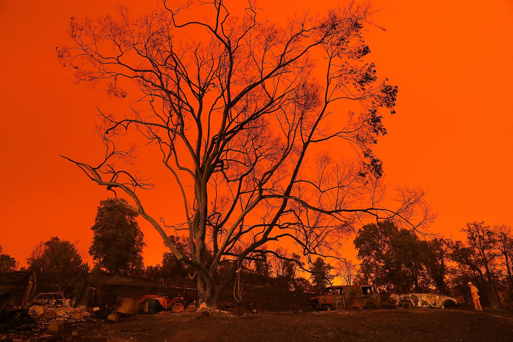
Meanwhile, the Carr Fire near Redding California continues to expand; taking lives, destroying property, mangling metal, and charring the landscape. As of August 2, the fire has spread across more than 126,000 acres.
But on July 26 another extraordinary thing happened. That evening there was a sudden extreme, upwards expansion in the fire. This rapid vertical growth created an updraft, a so-called vortex of wind, which eventually created what looked like a tornado. According to estimates by the National Weather Service, this fire-tornado had winds exceeding 143 miles per hour — equivalent to an EF3 tornado, which is on the more intense side of the 0-5 scale.
No, this is not a tornado. The Carr Fire in Shasta County created this rotation updraft. #CarrFire #California pic.twitter.com/CVvcafJBGK
— ABC10 (@ABC10) July 27, 2018
“This is historic in the U.S.,” Craig Clements, director of San Jose State University’s Fire Weather Research Laboratory, told BuzzFeedNews. “This might be the strongest fire-induced tornado-like circulation ever recorded.”
This level of strong winds over such a large area is extremely rare in wildfires. But big fires are becoming more common. With rising global temperatures, when heat combines with dry periods or comes in semi-arid locations, water evaporates more quickly, and the soil becomes drier, ultimately creating conditions that can lead to wildfires — dried out shrubs and trees ignite more easily.
And while California and the west is no stranger to wildfires, the fire season now runs almost year-round, with 2018 already worse than previous seasons.

This week’s series of stunning events, however, wasn’t contained to the United States.
In Sweden, which has seen record hot Arctic temperatures, the country’s highest peak is melting away. A glacier which sits on top of the southern tip of the Kebnekaise mountain in northern Sweden is no longer considered the country’s tallest point scientists said on Wednesday. The peak — the height of which has been measured since 1880 — is set to be surpassed by another mountain in a range further north which is not covered in ice.